
Heavy rains over the past few days, a burst of sunshine and warm weather were enough to inspire me to attempt paddling Pond Creek in southwest Jefferson County. Pond Creek is an utterly obscure paddling destination: I know no one who has paddled it and didn't find any information online. A couple of scouting trips and pondering over topographic maps, led me to decide on Sand Pit Ln as a launch site and the Hwy 44 bridge as a take-out, with an estimated travel distance of seven miles. I expected to find a lot of fallen trees blocking the route as well as heavy impact from urban development.
Pond Creek tempted me for many months before this trip. It stretches from the Outer Loop landfill to the Salt River in Bullitt County. I suspect its name originates from "The Big Pond" that once existed in the Outer Loop area known as the Wet Woods. At its northernmost extreme, it is little more than a concrete-lined ditch designed to ferry water away from Louisville as fast as possible, but its more southern region is what I wanted to explore.
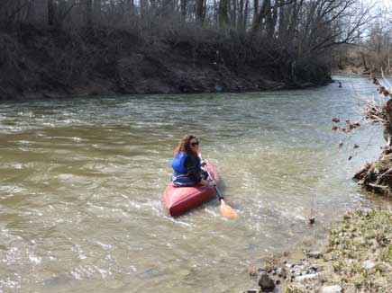
At 198 cubic feet per second (cfs) of flow, the put-in at Sand Pit looked very promising with a visible current and a few ripples. Sand Pit lane is gated, so we parked in the back of a subdivision next to it. Please be respectful and don't leave any trash. You'll see a rusty one-lane bridge and by that is a rock-lined drainage that makes a great launch site.
Not more that thirty feet across at its widest, the current of this little creek quickly carried us under the Gene Snyder. After a few minutes, we found our way blocked by a fallen tree. Such river-wide strainers are potentially deadly, but this one was easy to see approaching and to portage around. While I expected many such obstacles on this small creek, this was our only portage of the day.
Pleasantly surprising is how I sum up the afternoon. Pond Creek winds its way through the Ohio River floodplain, between the hills of the Knobs on the left and Dixie Highway on the right. The highway is never visible and not even audible for much of the trip. While much of the area is industrial, it is also practically abandoned. For example, the creek flows behind the cement plant in Kosmosdale, but the plant is a mile or so away. You see it (and the Mill Creek power plant in the distance), but empty fields separate you from them. In fact, the quiet was one of the most surprising facts. In sections, hemmed in by the creek banks, hills and trees, you might think you were in the middle of a nature preserve.
We spotted painted turtles, hawks, trees felled by beavers, wood ducks, kingfishers and an enormous sycamore tree with nearly a dozen nesting great blue herons. It's not pristine, though. Much of the bank is eroded and too steep to access. There are a few nice cottonwoods and sycamore trees, but much of the streamside has been overcut, leaving small trees and shrubs. You pass behind a few neighborhoods: a trailer park and ramshackle houses on one side of the creek, and small mansions on the other. Here and there, people dump brush and junk, and floating debris piles up behind fallen trees like a garbage-strewn Sargasso sea. There's even a historic junk yard of cars from the 1950s.

Once past the Pendleton Road bridge, the creek began to overflow its banks due to flooding from the Ohio River. We could literally paddle into the surrounding woods and the refrain from Born on the Bayou played in my head. As our anticipated three-hour trip stretched into four hours, I began to wonder if my map-reading skills needing some sharpening. Fortunately, a half-hour later, we spotted the Highway 44 bridge. It's best to take out on the downstream side of this bridge as the upstream side is clearly marked "no trespassing." A roadside pull-off is about 200 feet down the road where you can leave a second vehicle. Traffic was busy at rush hour, but people slowed down as we carried our kayaks back to the truck.
How often and what sections of Pond Creek can be paddled remains to be determined. Due to the flooding, our trip conditions were unusual. There are two USGS water guages: The first is near the Outer Loop and the second is at Pendleton Road. I suspect when the first guage is above 100 cfs, one is good to go.

Photos: Shawn Nevins